|
|
|
||||||||||||||||||||||||


Ruas de Liberty Bay: mudanças entre as edições
Ir para navegação
Ir para pesquisar

| [Aprovação Pendente] | [Aprovação Pendente] |
 Cuelo (discussão | contribs) (Criou página com '<imagemap> Image:LibertyBay Streets.jpg rect 121 112 198 115 Admiral's Avenue rect 166 115 169 180 Freedom Street rect 140 177 170 180 Freedom Street rect 140 180 143...') |
|||
| Linha 1: | Linha 1: | ||
<imagemap> | <imagemap> | ||
Image: | Image:Ruas de Liberty Bay.png | ||
rect 200 133 203 153 [[Trader's Point]] | rect 200 133 203 153 [[Trader's Point]] | ||
desc bottom-right | desc bottom-right | ||
| Linha 46: | Linha 8: | ||
{| border="0" cellpadding="1" cellspacing="0" | {| border="0" cellpadding="1" cellspacing="0" | ||
|- | |- | ||
|<span style="color: red"><b>Admiral's Avenue</b></span> || ([[Admiral's Avenue|*]]) | |<span style="color: red"><b>Admiral's Avenue</b></span> || ([[Admiral's Avenue|*]]) Rua horizontal da [[Sugar Street]] até à [[Valuables|joalheria]]. | ||
|- | |- | ||
|<span style="color: blue"><b>Freedom Street</b></span> || ([[Freedom Street|*]]) | |<span style="color: blue"><b>Freedom Street</b></span> || ([[Freedom Street|*]]) Rua vertical do [[depot]] até o norte da [[Admiral's Avenue]]. | ||
|- | |- | ||
|<span style="color: | |<span style="color: white; background-color: gray"><b>Ivy Circle</b></span> || ([[Ivy Circle|*]]) Um círculo em volta da torre de magia e da [[Tibian Explorer Society]]. | ||
|- | |- | ||
|<span style="color: | |<span style="color: #66EEEE"><b>Litter Promenade</b></span> || ([[Litter Promenade|*]]) Rua horizontal no sul das áreas mais pobres. | ||
|- | |- | ||
|<span style="color: # | |<span style="color: #753B19"><b>Klabauter Walk</b></span> || ([[Klabauter Walk|*]]) Rua horizontal pelo porto. | ||
|- | |- | ||
|<span style="color: | |<span style="color: purple"><b>Marble Lane</b></span> || ([[Marble Lane|*]]) Rua vertical da esquina ao norte da cidade até ao ''[[blacksmith]]''. | ||
|- | |- | ||
|<span style="color: | |<span style="color: brown"><b>Rum Alley</b></span> || ([[Rum Alley|*]]) Rua horizontal passando no norte do [[The Shelter]] nas áreas pobres. | ||
|- | |- | ||
|<span style="color: | |<span style="color: #99FF00; background-color: gray"><b>Shady Trail</b></span> || ([[Shady Trail|*]]) Rua vertical nos bairros pobres. | ||
|- | |- | ||
| | |<b>Smuggler Backyard</b> || ([[Smuggler Backyard|*]]) Rua vertical nos bairros pobres. | ||
|- | |- | ||
|<b> | |<span style="color: orange"><b>Straycat's Corner</b></span> || ([[Straycat's Corner|*]]) Rua vertical à leste dos bairros pobres. | ||
|- | |- | ||
|<span style="color: | |<span style="color: green"><b>Sugar Street</b></span> || ([[Sugar Street|*]]) Rua horizontal que se segue da parte oeste da cidade até a [[Admiral's Avenue]]. | ||
|- | |- | ||
|<span style="color: #FF0099"><b>Trader's Point</b></span> || ([[Trader's Point|*]]) Rua horizontal indo pelo templo e pelo norte do [[depot]]. | |||
|<span style="color: #FF0099"><b>Trader's Point</b></span> || ([[Trader's Point|*]]) | |||
|} | |} | ||
Edição das 19h58min de 26 de maio de 2012

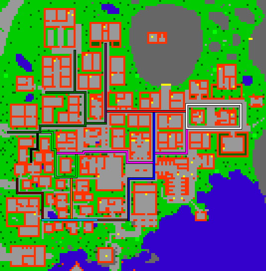
Clique nas ruas coloridas para ir à página correspondente.
| Admiral's Avenue | (*) Rua horizontal da Sugar Street até à joalheria. |
| Freedom Street | (*) Rua vertical do depot até o norte da Admiral's Avenue. |
| Ivy Circle | (*) Um círculo em volta da torre de magia e da Tibian Explorer Society. |
| Litter Promenade | (*) Rua horizontal no sul das áreas mais pobres. |
| Klabauter Walk | (*) Rua horizontal pelo porto. |
| Marble Lane | (*) Rua vertical da esquina ao norte da cidade até ao blacksmith. |
| Rum Alley | (*) Rua horizontal passando no norte do The Shelter nas áreas pobres. |
| Shady Trail | (*) Rua vertical nos bairros pobres. |
| Smuggler Backyard | (*) Rua vertical nos bairros pobres. |
| Straycat's Corner | (*) Rua vertical à leste dos bairros pobres. |
| Sugar Street | (*) Rua horizontal que se segue da parte oeste da cidade até a Admiral's Avenue. |
| Trader's Point | (*) Rua horizontal indo pelo templo e pelo norte do depot. |